I started the day with good intentions…
I really did…and you know what “the road to hell is paved with….” Today was going to be a “run the reports, square away the accounting, put up the Christmas tree, and send out some business letters” kind of day.
Then, at about 10:30 AM, my future son-in-law showed up with the ominous announcement that he had “come for me.” He wanted me to accompany him on a motorcycle ride south of town, on Mines Road. I dressed, then checked the temperature: 45 ℉. I know that those of you in lands of ice and snow would trade valuable body parts for 45 ℉ right now, but it got me thinking about “wind chill,” something that I have not done too often since graduate school in Madison, WI. Although the NOAA wind chill chart linked above starts at 40 ℉ and goes DOWN, wind chill can be calculated for objects like motorcycles creating their own wind, at higher air temperatures. At 45 ℉ and 55 mph through still air, the wind chill makes it feel like 17 ℉, according to the calculator.
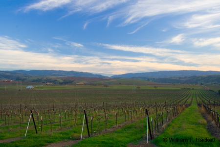
Mines Road starts as a two lane highway going south from Livermore, and then slowly deteriorates.  One of my favorite California road signs is along Mines Road – “No shooting on or upon public road….” Some of my “shots” of scarecrows in the vineyards were taken on Mines Road, and wild turkeys can often be found on Mines Road in abundance, since there is running fresh water nearby. Today we saw neither. The motorcycle forum here has a good map of the route that we took: south on Mines Road to “The Junction”, east on Del Puerto Canyon Road to Interstate 5, north on I-5 to Corral Hollow Road, and West on Corral Hollow Road and Tesla Road back to Livermore. The forum also describes Mines Road accurately: “Mines is one of those roads that ALWAYS seems to have some hazards strewn about… pea gravel in the corners, some rockfall, heaves in the pavement on some curves, single-lane road for a good portion of it”
A writer to the forum added this comment in November: “A yellow 996 Ducati high sided about 5 miles out…” Charles Darwin would have loved Mines Road.
My future son-in-law “dragged me through the twisties” (motorcycle-speak for my following slowly behind him as he skillfully navigated the many, many curves, often above a potentially precipitous fall into the valley far below. The road climbs about 2000 feet (to 2500 feet of elevation) on its way to “The Junction”. I told him that I wanted to stay close enough to him so that he would not lose me, and far enough back that I would not be hit by debris (from his wreck). Although the road has light traffic, the gravel, rockslides, water from springs and rain, ice and snow at some times of the year, bicycle traffic, motorcycle traffic, possible plunge to the valley, hairpin curves, lack of guardrails, and the occasional oncoming-pickup-truck-in-your-lane all combine to make Mines Road an exciting ride. Oh, I forgot to mention the cattle – both range cattle and the escaped-couple-of-cows-with-calves that we saw today.
All the while, I wished I had my camera with me. There were beautiful sweeping vistas, backlit trees with “fall” color, occasional ponds and streams, and rock formations. When I shot photos of kite boarders and wind surfers on the San Mateo coast, I had my camera and tripod and talked to a motorcyclist who wished that he had his camera; I wished that I had my motorcycle then. Too many passions…too little time.
In any case, we arrived at “The Junction” intact. The junction of Mines Road and Del Puerto Canyon Road now has a “biker bar” and a California Department of Fire station. “The Junction” biker bar/cafe/restaurant (I don’t know what to call it – it has a “hat tree” for helmets outside the door) was serving a lot of coffee, tea, and hot chocolate today. Also, the wood stove/fireplace insert was going strong, and folks were taking turns warming themselves. Behind the bar were 4 mounted heads of wild boar, and the head of a buck was mounted on the wall near the door. There is a porta-potty outside, as well as a pay phone (cell phones are useless on this ride) and full facilities inside, including a pool table. Several motorcyclists inside had traveled up Del Puerto Canyon Road that morning, so I asked about mud and debris from a recent rain; the road sounded safe for travel.
After about 3 cups of coffee, and after my future son-in-law had warmed up the outside by the fire and the inside with cups of tea, we were ready to travel down Del Puerto Canyon Road, a new road for him. Del Puerto Canyon was the origin of a fire in 2006 that consumed 34,217 acres, with 11 residences and 5 outbuildings destroyed and 1 residence and 5 outbuildings damaged. There were also 10 injuries associated with the fire.
If the description of Mines Road above sounded intimidating, Mines Road is a walk-in-the-park compared to Del Puerto Canyon Road, which is both narrower in spots and not as well maintained, overall. (My comment to my companion was, “They fixed the road!”) Del Puerto Canyon is loved by birders, geologists, and even more birders… not to mention the motorcyclists and bicyclists. The California Highway Patrol (CHP) were busy with some folks at Rough Terrain, an all-terrain-vehicle and hill-climb area (2000 acres) also known as the Frank Raines Off Highway Vehicle Park. We stopped at the picnic area of the park on the south side of the road, and then continued eastward and downward to the Central Valley town of Patterson. The road has some nice sweeping curves in the lower sections, punctuated by spectacular rock formations, surprise hairpin curves, and other opportunities to launch your 2-wheeled- or 4-wheeled-vehicle into the canyon creek bed below. Darwin would have loved Del Puerto Canyon Road, too – a thought that also crossed my mind when I saw two brand-new log homes that had been constructed in the canyon that had been ravaged by fire in 2006. Some eastern sections of the road are bordered on both sides by barbed-wire fencing, which kept one cow we passed trapped ON the roadway. Eventually we made our way to the cluster of gas stations and fast food establishments that make the I-5 exit at Patterson an oasis for travelers. I remember when none of the buildings were there.
The speed limit on I-5 North is 70 mph, a fact that many Californians regard as a polite suggestion. My companion’s progress was made more difficult (I won’t say “slowed” ) by the fact that his bike had no windshield. It is often windy in that area (hence the windmills), and it is always windy at “Mach 2.” We took the Corral Hollow Canyon Road exit. This road becomes Tesla Road on its way to Livermore, and passes the Carnegie State Vehicle Recreation Area (read “dirt bikes and hill climbs”) and Lawrence Livermore Laboratory’s Site 300, which was established in 1955 as a non-nuclear explosives test facility, as well as the locations of the early towns of Carnegie and Pottery, and the coal-mining town of Tesla, with mines that made the town the largest producer of coal in California from 1897 to 1905. The mines closed in 1911; Tesla became a ghost town, and after all the buildings were destroyed, a town site.
The climb out of Corral Hollow, with its hairpins and changing-radius curves is also fairly exciting, but not as exciting as the descent when traveling eastward. We traveled Tesla Road through the vineyards, and back home. When I checked the thermometer on my back porch, it read 54 ℉. I did not even want to think about the wind chill at some of the speeds and locations of our trip. Instead, I made a sandwich and thought about some of the high points of our day, preparing for a trip WITH a camera, next time…
-Bill at Cheshire Cat Photo™
You can view higher-resolution photos (*generally* 7-30 megabytes, compressed) at the Cheshire Cat Photo™ Pro Gallery on Shutterfly™, where you can also order prints and gifts decorated with the photos of your choice from the gallery. Apparel and other gifts decorated with some of our most popular photos can be ordered from the Cheshire Cat Photo™ Store on CafePress®.


