Ride through the vineyards
Today, it was 60 degrees F at 3 PM, and I decided that I was overdue for a motorcycle ride through the vineyards. Firstly, I needed a ride. Those of you who ride motorcycles know how difficult it is to translate the experience to those who do not. There has been a lot of good stress and bad stress for me lately,  and a motorcycle ride is a great stress reliever. Secondly, the bike needed a ride. Although I had started up the engine of the black 1100cc Honda Shadow Spirit about 3 weeks ago, it had been over a month since I had ridden. As the time drew near for me to walk my daughter down the aisle, I thought, “Why take any unnecessary risks?” “Why limp down the aisle?” Thirdly, the 1 week of dry, beautiful spring weather, which had been preceded by 2 weeks of rain, is about to end. We do not complain about rain in California, but we try to work around it. Rain can be very bad for friction (see below), especially rain + oil.
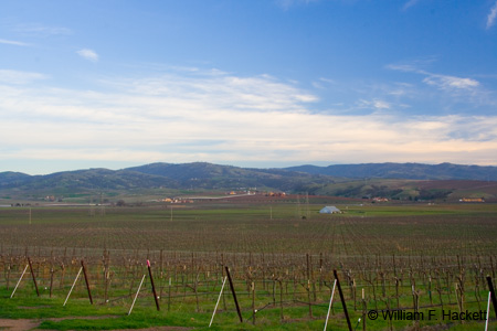
I decided to take a motorcycle ride on behalf of those of you motorcyclists out there who cannot! What good is having some of the best weather in the continental U.S. if you don’t use it. The bike started up, first try, and I let it idle for 30 seconds at full choke before letting off the choke and starting out. I noticed the increasing humidity as I rode down Concannon, and I noticed the sawhorses in place, just in case the third leg of the Amgen Tour of California Bicycle Race should be re-routed through Livermore. There was filtered sunshine through increasing high cloudiness as I rode along Concannon, and I noticed a cool moist “thickness” in the air, which can be quite dry here at other times of the year. I rode past some vineyards and caught the light to make the right turn on Tesla Road, home to vineyards on both sides (1, 2) of the road.I took a left at Greenville Road, and rode north past Lawrence Livermore National Laboratory. past Patterson Pass Road, where I had recently photographed one of Livermore’s oil wells, and turned left on North Front Road. I rode on past Laughlin Road, entrance to the Brushy Peak Regional Preserve, and got in line to turn right onto Vasco Road. Vasco Road turns deadly north of town and becomes the site of numerous head-on collisions in which impatient (and stupid) California drivers cross the double-yellow line to gain a few minutes of time in their commutes to and from Brentwood and places beyond. I have turned the bike around in heavy fog (as in “beading up on windshield” heavy fog) on Vasco Road, only to see pickup trucks speeding along with visibilities of less than 50 feet.
Today, however, I turned left on Dalton Avenue, the last left at the edge of town, and followed it to the sharp 90-degree right turn on Ames Street, dropping down to second gear to avoid straying into the path of an oncoming truck. The turn is not banked and must take a few people by surprise. In less than half a mile, Ames Street takes a 90-degree *left* turn to become Raymond Road, a turn that likewise is not banked and had gravel in it. Gravel is stuff that just makes pretty pinging noises to you four-wheeled vehicles out there, but is substantially more important to motorcyclists, who count on friction (even more than you do) to make turns. A garden-variety (he passed *legally*) impatient idiot passed me on Raymond Road before Dagnino Road, and both of us took the 90-degree left turn (with gravel) onto Lorraine Street. Lorraine is a straightaway (as is most of Raymond), but both have 90-degree curves at both ends, to prove Darwin right. I up-shifted and accelerated past the air-quality monitoring station and down-shifted to second for the 90-degree right turn onto Hartford Avenue, home of old Aeromotor windmills on both the south and north sides of the road.
I should mention at this time that all along my route I kept meeting meeting fellow motorcyclists (and giving them the “hi” sign), as well as bicyclists. All of us were opportunists, hoping to wring the hours before the next days of rain for all of the enjoyment that we could. The bicyclists also were probably inspired by the news coverage of the Tour of California, now in its third year. Hartford is also a well-paved straightaway, which “T’s” into North Livermore Avenue, also as a tribute to Darwin.
The right turn onto North Livermore Avenue put me onto a L-O-N-G straightaway, which usually has a hidden police officer to enforce the 55-mph speed limit. This time however, there were 3 police vehicles and no civilians near the electrical substation. Wanting no part of this meeting, I continued on. At the northern end North Livermore Avenue is a “rumble strip” to alert traffic of the upcoming 15-mph 90-degree turn to the left, onto Manning Road. Manning veers to the right, mercifully, and then to the left, before executing a delicate series of generally rightward turns past a ranch that I photographed last week. Along Manning is an earth embankment, which generally signals residential development. The whole area there, being level, is probably doomed to development eventually.
When I got to the ranch I had photographed, I noticed that a rare (and hopefully endangered) species of California litterbug had dropped an upholstered chair in the middle of this scene that I photographed a little more than a week ago. Anyone will tell you that I am not an anal-retentive “neat freak,” but I really have a problem with the mindless slobs that trash our natural world, or even the more natural aspects of our “civilized” world. And yet, putting a bounty on the heads of these folks would probably offend the delicate sensibilities of many Californians.
There is a deceptively gentle left turn in Manning Road that, also being unbanked (do you see a pattern here?) would lead a motorist or motorcyclist into a rocky ditch and the barbed wire fence beyond. I took a left at the “T” with Carneal Road, and another left at the “T” with Collier Canyon Road, past Las Positas College and onward to Costco, to gas up the bike ($5.25 at $3.019/US gallon). From there, it was back home.
I rejoice that I can take a motorcycle ride in February, especially when I really need it and the bike does too! The year 2000 bike has almost 27,000 miles on it, many of them hard, greasy, Silicon Valley miles. Since gas prices appear to be on their way up again, I am certain to be traveling more on the bike as the weather improves.
-Bill at Cheshire Cat Photo™
You can view higher-resolution photos (*generally* 7-30 megabytes, compressed) at the Cheshire Cat Photo™ Pro Gallery on Shutterfly™, where you can also order prints and gifts decorated with the photos of your choice from the gallery. Apparel and other gifts decorated with some of our most popular photos can be ordered from the Cheshire Cat Photo™ Store on CafePress®.


