Preserving Wonderland: Brushy Peak Regional Preserve
Lately, I have been feeling like an “unintentional archivist.” Local development of lands both north and south of Livermore means that some areas that I have photographed in recent years will never look the same again. I know that this phenomenon occurs all over the United States and in other countries, and for everything gained, there is something lost.
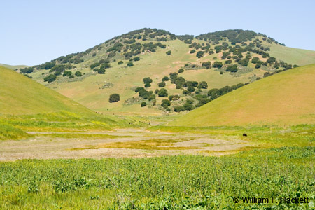
So I was pleased today to see a brown sign on Northfront Road, which parallels I-580 in Livermore. The brown sign said, “Brushy Peak Regional Preserve” and pointed north on Laughlin Road. I could not resist. A few years ago, I took a motorcycle ride up Laughlin Road until the road turned northeast into the hills and became a private road. Then, I turned the bike around. Today, I drove north on Laughlin Road, and as I did so, *hundreds* of gulls took off from Frick Lake, leaving hundreds more behind! Frick Lake is an intermittent lake just east of Laughlin Road, before the road turns northeast into the Altamont. Today, the lake has water in it, but there was “No Parking” along the shoulder, and a paved curb to discourage it. However, as the road turned northeast and narrowed, the “private road” sign was no longer there. The road continued, dead-ending at a parking lot for cars and one for cars with horse trailers at the Brushy Peak Regional Preserve. Brushy Peak is a 1702-foot landmark that has been recognized as sacred by native Californians. The peak is at the juncture of the Bay Area, the Delta, and the Central Valley.
(Update April 23, 2008: My later visit to Brushy Peak Regional Preserve, linked to some of the photos that I took, is here.)
Historically, the area is at the center of a network of Native American trade routes. Brushy Peak is probably most closely associated with the Ssaoam triblet of the Ohlone people, who lived in the dry hills and small valleys around Brushy Peak and the Altamont Pass. The Ssaoam acted as brokers in a regional trade network with the Volvons, a tribelet of the Bay Miwok, and the Tamcans of the Northern Valley Yokuts. In 1772 Pedro Fages made the first European expedition into west-central California and passed through the Livermore Valley on his way back to Monterey. The Ssaoam people lived at Mission San Jose in what is now Fremont, from 1806 to 1836. By the mid-1800’s, the mission lands were divided into Mexican ranchos. By 1846, at the end of the Mexican-American War, these lands became part of the United States. During the Gold Rush, rocky outcrops of Brushy Peak became a haven for bandits, and a favorite retreat of the legendary Mexican bandit, Joaquin Murrietta. During the 1870’s, homesteads were established on and around Brushy Peak. Between the 1890’s and World War I, ranch families held picnics and dances on the peak, and during the 1920’s and 1930’s, Joseph Laughlin built farm buildings on the property. In 1994, the Livermore Area Recreation and Park District (LARPD) acquired 507 areas of the area as parkland.
Non-native plants include ryegrass, wild oats, and soft chess. Native perennial grasses include purple needlegrass and creeping wildrye. Saltgrass is found in the alkali seasonal wetlands. Native wildflowers include fiddlegrass, the California buttercup, Johnny jump-up, lupine, blue-eyed grass, and many others. Grassland wildlife include ground squirrel, amphibians, reptiles, badgers, burrowing owls, squirrels, cottontails, red-tailed hawks, golden eagles, western meadowlarks, rock wrens, and the San Joaquin kit fox. Oak woodlands support deer, bobcats, rodents, cedar waxwings, orioles, robins, woodpeckers, and various raptors. Spring-fed ponds that were constructed by ranchers provide habitat for the federally protected California red-legged frog and the California tiger salamander.
Brushy Peak offers opportunities for hiking, biking running, nature study, and dog walking. I am delighted that the area is now accessible for these activities, barring any future restrictions in the event of budget cuts. Importantly, these lands are protected from the development that is currently sprawling across the nothern portions of the the Livermore Valley.
-Bill at Cheshire Cat Photo™
You can view higher-resolution photos (*generally* 7-30 megabytes, compressed) at the Cheshire Cat Photo™ Pro Gallery on Shutterfly™, where you can also order prints and gifts decorated with the photos of your choice from the gallery. Apparel and other gifts decorated with some of our most popular photos can be ordered from the Cheshire Cat Photo™ Store on CafePress®.


