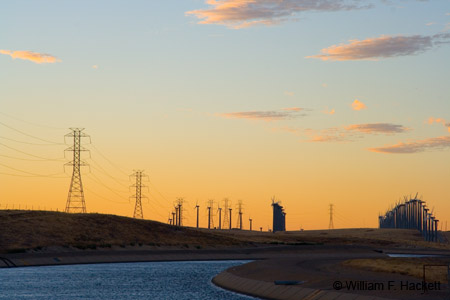
The California Aqueduct

The Governor Edmund G. Brown California Aqueduct is a system of pipelines, canals, and tunnels that carry water from the Sierra Nevada and valleys of Northern and Central California to Southern California. The California Aqueduct and two pumped-storage hydroelectric plants, Castaic and Gianelli, are operated and maintained by the Department of Water Resources.
The aqueduct starts at the San Joaquin-Sacramento River Delta (a rare example of an inverted river delta) at the Banks Pumping Plant which pumps water from the Clifton Court Forebay (1, 2) to Bethany Reservoir (1), which serves as the forebay for the South Bay Pumping Plant that feeds the South Bay Aqueduct. From Bethany Reservoir, water flows by gravity for approximately 60 miles (97 km) to the O’Neill Forebay at the base of the San Luis Dam of the San Luis Reservoir, the largest off-stream reservoir in the United States. From the O’Neill Forebay, water flows about 50 miles (80 km) to the Dos Amigos Pumping Plant, from where it flows about 95 miles (153 km) to where the Coastal Branch of the aqueduct splits from the “main line” at about 16 miles (26 km) south-southeast of Kettleman City. The Coastal Branch delivers water to the cities of San Luis Obispo, Santa Maria, Santa Barbara, and through extensions to Lompoc, Buellton and Solvang, terminating at Lake Cachuma in the Los Padres National Forest.
After the Coastal Branch splits off, the main line flows by gravity for 66 miles (106 km) to the Buena Vista Pumping Plant, then for 72 miles (116 km) to the Chrisman Pumping Plant, then for 13 miles (21 km) to the Edmonston Pumping Plant (1), which pumps water upward 1926 feet (587 m) over the Tehachapi Mountains.
After water flows over the Tehachapi Mountains, the aqueduct divides into two more branches: the East and West Branches. The East Branch supplies Lake Palmdale and terminates at Lake Perris near the San Gorgonio Pass. The West Branch terminates at Pyramid Lake and Castaic Lake in the Angeles National Forest.
The water flow in the aqueduct abruptly rises at the pumping stations and gradually falls along the route as it flows by gravity. Where there are substantial drops, some of the energy of the falling water is recaptured at hydroelectric plants.
A typical section of the aqueduct has a croncrete-lined channel 40 feet (12 m) at the base and an average water depth of about 30 feet (9.1 m). The widest section of the aqueduct is 110 feet (34 m), and the deepest is 32 feet (9.8m). Channel capacity is 13,100 cubic feet (370 cubic m) per second.
As I have said before, California is “very much about water.” The engineering of the California Aqueduct, and the ongoing political, economic, and environmental “discussions”  about water use underscore the likelihood that California will always be very much about water.
-Bill at Cheshire Cat Photo™
You can view higher-resolution photos (*generally* 7-30 megabytes, compressed) at the Cheshire Cat Photo™ Pro Gallery on Shutterfly™, where you can also order prints and gifts decorated with the photos of your choice from the gallery. Apparel and other gifts decorated with some of our most popular photos can be ordered from the Cheshire Cat Photo™ Store on CafePress®. Both Shutterfly™ and CafePress® ship to most international locations worldwide!Framed prints and prints on canvas can be ordered from our galleries on imagekind® and redbubble®. If you don’t see what you want or would like to receive an email when new photos are up on the site, send us an email at info@cheshirecatphoto.com.


