Marin Headlands
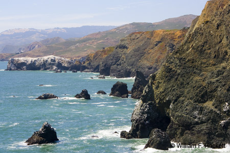
The Marin Headlands is an area at the southern end of Marin County, across the Golden Gate to the north of San Francisco. The headlands have a SPECTACULAR view of the Bay Area and the Golden Gate Bridge, depending of course on fog and the clearing of the unusually smoky air (from wildfires) that we have experienced recently.
Of course the Point Bonita Lighthouse is at the southwestern tip of the Marin Headlands. The headlands comprise one portion of the distributed Golden Gate National Recreation Area.
The hills of the Marin Headlands can create their own clouds when warm Pacific Ocean air is pushed into colder air above. It is quite a sensation to start your trip in clear weather, climb into a cloud with large drops of water hitting your windshield, and then descend into clear weather later in your trip. See the Wikipedia article for a discussion of climate – local people say that they can spot tourists shivering in the summertime in their shorts and T-shirts at the northern end of the Golden Gate Bridge.
Wildlife is abundant in the Marin Headlands and ranges from raptors in the tens of thousands (Hawk Hill at 920 feet [280 m] is the lookout point, especially from August through December) such as hawks, kites, osprey, eagles, falcons, harriers, and vultures – to deer, bobcats, racoons, rabbits, coyotes, and skunks. Waterfowl and seabirds can often be seen on Rodeo Lagoon and can include brown pelicans, grebes, surf scoters, common murres, egrets and Great Blue Heron. Harbor seals are in the water year round and gray whales are seen in the spring and fall.
The land itself has been occupied by the Native American Coastal Miwok, to Spanish and Mexican ranchers, to Portuguese dairy farmers (no doubt with “happy cows”), to the military. There are a number of historic military fortifications and buildings on the Marin Headlands, including Fort Cronkite and Fort Barry, bunkers and batteries (1) from pre-World War I to World War II, observation posts (up there on the ocean side of the hill) known as base end stations, and the SF-88 Nike Missile silo, (this site can be visited, and there are a number of other old Nike Missile sites scattered around the Bay Area).
Recreational opportunities at the Marin Headlands include a number of beaches, including Rodeo Beach, hiking, biking, photography, birdwatching, and first-hand opportunities for history and geology buffs. A map of the area is here (PDF).
Some of the groups that have facilities on the Marin Headlands are the Marine Mammal Center, the Headlands Institute, the Foundation for Deep Ecology (all in Fort Cronkite), the Headlands Center for the Arts and the Marin Headlands Hostel at Fort Barry.
-Bill at Cheshire Cat Photo™
You can view higher-resolution photos (*generally* 7-30 megabytes, compressed) at the Cheshire Cat Photo™ Pro Gallery on Shutterfly™, where you can also order prints and gifts decorated with the photos of your choice from the gallery. Apparel and other gifts decorated with some of our most popular photos can be ordered from the Cheshire Cat Photo™ Store on CafePress®. Both Shutterfly™ and CafePress® ship to most international locations worldwide! Would you like to receive an email when new photos are up on the site? Send us an email at info@cheshirecatphoto.com


