Sutro Tower
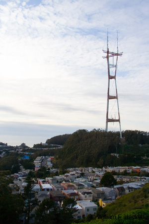
Sutro Tower is a 977-foot (298-m) self-supporting steel tower in the western part of San Francisco. The tower was built to provide television, high-definition television, radio, and additional communication services, given the hilly topography of the Bay Area. The physical address of the tower is 1 La Avanzada Street, San Francisco, just southwest of Mount Sutro, on an adjacent and connected hill. The tower was named after Adolph Sutro, a businessman, engineer, and the 24th mayor of San Francisco.
The Sutro Tower site is the original location of the Sutro Mansion (PDF) built in the 1930’s by Adolph Gilbert Sutro (1891-1981), who was an aviator and adventurer and the grandson of the former mayor. The villa, La Avanzada, was the home of Sutro and his mother until they relocated to land near Mission San Luis Rey de Francia. Sutro sold the house and land to the American Broadcasting Company in 1948, for $125,000 (USD).
Sutro Tower was designed by Albert C. Martin & Associates of Los Angeles, California and fabricated and erected by Kline Towers, a subsidiary of Kline Iron and Steel of Columbia, South Carolina. The groundbreaking for the construction occurred in 1971 and the tower was completed in 1972. The first transmission from the tower occurred on July 4, 1973. Sutro Tower was constructed to withstand seismic activity. The foundation was made with about 15 million pounds (6.8 million kilograms) of concrete. The tower itself weighs about 3.7 million pounds (1.7 million kilograms), and this engineering combination places the center of gravity of the combined structure below ground. The base of the tower is 834 feet (254 m) above mean sea level, and the total height of the tower above mean sea level is 1811 feet (552 m). The current owner and operator of the tower is Sutro Tower, Inc., an independent corporation founded in 1968 by the owners of the stations KTVU2, KRON4, KPIX5, and KGO-TV7.
Sutro Tower is at the coordinates 37 deg 45′ 18.72″ N, 122 deg 27′ 8.64″ W and is the tallest structure in the Bay Area.
-Bill at Cheshire Cat Photo™
You can view higher-resolution photos (*generally* 7-30 megabytes, compressed) at the Cheshire Cat Photo™ Pro Gallery on Shutterfly™, where you can also order prints and gifts decorated with the photos of your choice from the gallery. Apparel and other gifts decorated with some of our most popular photos can be ordered from the Cheshire Cat Photo™ Store on CafePress®. Both Shutterfly™ and CafePress® ship to most international locations worldwide!


