The Merced River
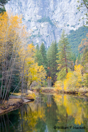
The river that was named El Rio de Nuestra Señora de la Merced (River of Our Lady of Mercy) in 1806 by an expedition led by Gabriel Moraga has its headwaters in the southern half of Yosemite National Park. The river flows into Yosemite Valley (photo above is in fall; see also winter, spring [Note added June 11, 2009: …and another spring]).
Much of the water of the Merced River is stored in Lake McClure and diverted by the Merced Irrigation District. The remaining water flows southwest across the San Joaquin Valley to join the San Joaquin River. A very nice map (with photos) of the Merced River watershed and Merced Irrigation District canals is here (PDF file). The Merced River is protected under the National Wild and Scenic Rivers Act and is free-flowing until Lake McClure. The river tends to flood in the winter and spring and then dramatically decrease in volume in the summer and fall. Highway 140 runs along a portion of the Merced River and is a main road into Yosemite Valley. Highway 140 is a good road to use to visit Yosemite Valley in winter, since it is lower in elevation than other roads and may not have a requirement for tire chains (always check road closings and chain requirements in advance of your travel [National Park Service, California Highway Patrol]). However, be aware that runoff water and mist can freeze on the surface of Highway 140 forming dangerous black ice. (Note added August 16, 2008: I have personally slid on black ice on 140 along the Merced. I was driving very slowly, and there was no damage or injury.) Some 600 feet of Highway 140 were closed between El Portal and Mariposa (Spanish for “butterfly“; named by the Moraga expedition for the abundance of butterflies) in June of 2006 from a rock slide (the Ferguson Slide). In one flood year while I have lived in California, sections of Highway 140 leading to Yosemite Valley (and homes and businesses) were destroyed in the Merced River Canyon by flooding and had to be replaced. There are still signs posted in Yosemite Valley with high-water marks from that year.
The main branch of the Merced River is 112 miles (180 km) long. Other branches of the river include the North Fork, South Fork and Lyell Fork. Much of the river has been “improved” to facilitate fish spawning. The rare species, limestone salamander ((Hydomantes brunus) is endemic to the Merced River Canyon. Several abandoned gold mines also lie along the Merced in the canyon.
Recreational opportunities along the Merced River include: whitewater rafting, fishing, kayaking, hiking, camping, swimming, and picnic areas for “recharging.”
Although Highway 120 is a faster and slightly shorter route from where I live to Yosemite, I will occasionally take Highway 140 for the scenic beauty along the banks of the Merced River. If I have time, I will go by one route and come back the other! In spring, the flowers and flowering trees along the Merced are phenomenal and the river itself is majestic!
Enjoy!
-Bill at Cheshire Cat Photo™
You can view higher-resolution photos (*generally* 7-30 megabytes, compressed) at the Cheshire Cat Photo™ Pro Gallery on Shutterfly™, where you can also order prints and gifts decorated with the photos of your choice from the gallery. Apparel and other gifts decorated with some of our most popular photos can be ordered from the Cheshire Cat Photo™ Store on CafePress®. Both Shutterfly™ and CafePress® ship to most international locations worldwide!


