Photography and GPS
I see from articles on geotagging and the incorporation of gps receivers into high-end cameras that photographers have discovered the wonderful world of gps! I certainly do not consider myself an “early adopter” of gps, even though I have been using gps for a number of years. The association of gps coordinates with photographs lends an entirely new dimension to photography. (Geocaching is another phenomenon, and not considered here.)
An interesting project that a coworker at Sun® pointed out to me (probably 5 years ago) is the “Degree Confluence” Project. According to the site, “The goal of the project is to visit each of the latitude and longitude integer degree intersections in the world, and to take pictures at each location. The pictures, and stories about the visits, will then be posted here (at the web site).” This is a pretty cool concept, if you think about it, especially since it was started *long* before geotagging and long before Google™ Earth. Check out the site!
So, how do I use gps with photography? Some scenic locations with really marvelous views are good to know about *before* you reach them. I am specifically thinking about some pullouts on Highway 1 in Big Sur. Once you are past the location, it is *very* difficult, if not impossible, to turn around. The locations are not always easy to remember visually (a wall of rock on one side of the road and a 300-foot drop into the ocean on the other – a lot of places look like that  ).
).
Another good use of gps is to establish waypoints for shooting locations in a totally unfamiliar place (Kauai was like that for me). This use of gps also works for very remote places or places with few landmarks (spots along the Tioga Road in Yosemite come to mind). Even if you research your shooting location very well in advance, there will *still* be unfamiliar features of the landscape (Hey! What’s the name of that mountain?). With waypoints stored and a reasonable sense of direction (I also carry a compass), you can unload the waypoints when you return and identify features on a calibrated map.
Ah yes, …calibrated maps. The gps unit that I received as a gift years ago (and still use) is a “ruggedized” Garmin™ eTrex Legend®. Garmin™ has not had the vision to support Macintosh® users until the last few years, and now, only partially. Fortunately, when my high-tech employer gave me a Windows® laptop and administrative rights to that laptop, I could easily load different (Garmin™-proprietary) background maps from my Topo U.S. Garmin™ CDs into the gps handheld unit. The eTrex Legend® only has 8 MB of storage space for maps. My last high-tech employer did not grant most employees administrative rights, so I had the maps for the Bay Area in the gps unit during that job, since the Bay Area and surrounds is where I did most of my traveling. The problem of loading Garmin™-proprietary maps into the Garmin™ gps receiver was resolved when I helped a friend move, and she gave me her old Windows® machine, rather than donate it elsewhere. I keep the Windows® box *off* the network and use it primarily to load topographic maps onto the handheld gps. Windows® machines are pretty safe until you network them – they make great (unnetworked) “game machines” .
For general gps use on Macintosh®, I use the MacGPS Pro™ program by James Associates. This program serves all of my gps needs *except* loading proprietary Garmin™ maps into the Garmin™ gps unit itself. Garmin™ representatives at Macworld San Francisco told me that it is possible to load Garmin™ maps into their gps units from an *Intel®* Macintosh® using the Parallels® desktop for a virtual PC environment. Other virtualization software might work as well.
There are many sources of free maps on the Internet (e.g. the California Spacial Information Library [CaSIL] MapSurfer program. I started out by converting DRG maps at the USGS site for the Bay Area to MacGPS Pro™ format, and then ultimately bit the bullet and bought a set of DVDs for the entire state of California from James Associates (hey, my time is worth money, too!).
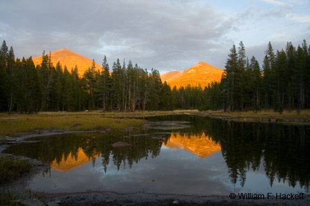
When I shot sunset photos of two mountains illuminated along the Tioga Road, I confirmed the names of the mountains and the stream by placing waypoints on MacGPS Pro™-calibrated USGS topographic maps after my return home. In Hawaii, this method even allowed me to get the spelling right .
Now, folks are submitting geotagged photos to Flickr™. Google™ Earth provides capabilities that were unknown a few years ago. I am a great fan of the BBC documentary series Connections, with James Burke, a series that (according to the WikiPedia reference above) “demonstrates how various discoveries, scientific achievements, and historical world events built off one another in an interconnected way to bring about particular aspects of modern technology…Connections explores an “Alternative View of Change” (the subtitle of the series) that rejects the conventional linear and teleological view of historical progress.”
Thinking has been discribed as “linear” or “random”. Linear thinkers will usually “get you there” (from point A to point B to point C to point D to point E) but nonlinear thinkers will often “get you there” much faster . I have worked for enough linear thinkers to be absolutely sure of that. (I think “network” thinker is a better description than “random” thinker – it’s not really random; it’s just that linear thinkers describe as “random” the phenomena that they can’t figure out! ).
Advances like those wrought by Google™ Earth mean that we have not even begun to think of all of the combined uses of photography with gps. It might be worthwhile to spend some “blue-sky thinking” time on some of them. I will.
-Bill at Cheshire Cat Photo™
You can view higher-resolution photos (*generally* 7-30 megabytes, compressed) at the Cheshire Cat Photo™ Pro Gallery on Shutterfly™, where you can also order prints and gifts decorated with the photos of your choice from the gallery. Apparel and other gifts decorated with some of our most popular photos can be ordered from the Cheshire Cat Photo™ Store on CafePress®.


