Brushy Peak Regional Preserve: a warm visit
Today, I hiked into the Brushy Peak Regional Preserve, north of Livermore, about which I blogged earlier. I will not rehash the earlier blog entry, which describes the history, flora, and fauna of the area. Rather, I will give some impressions and advice concerning the areas that I visited, to aid the hiker and photographer. I will revisit the topic of Brushy Peak Regional Preserve when the photos that I took today are uploaded.
(Update April 22, 2008: I uploaded the photos today and use some of them below to illustrate this blog entry.)
Brushy Peak is a 1702-foot landmark at the juncture of the San Francisco Bay Area, the California Delta, and the Central Valley. Parts of the Preserve (including the peak itself) constitute a “Resource Protection Area”, and can be visited only by reservation (Livermore Area Recreation and Park District, 925-373-5707). In retrospect, today was not the day to visit Brushy Peak, at least not by the route that I took initially. Although it was supposed to be cooler in Livermore today than yesterday’s 87 degrees F, it was 89 degrees F at 3 PM, instead. I noticed that Frick Lake, the intermittent lake that harbored the thousands of gulls in my earlier blog entry, had dried up completely. I proceeded to the Laughlin Ranch Staging Area.
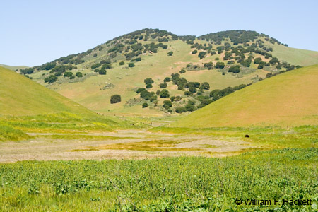
Contrary to the brochure, there is now a tap for drinking water at the parking lot, as well as a restroom. There are also brochures for Brushy Peak and for Round Valley. After putting on hiking boots, camera backpack, fanny pack, tripod sling, hat, and two water bottles, I stopped near the parking lot at the staging area to photograph Brushy Peak (above). Then, I proceeded to the gate to the West Side Loop Trail (please do not let the grazing cattle escape). I stopped to photograph a male and female mallard (it’s that time of year!) at a small pond near the gate, and a view of a watering trough with two flowering trees that served to shelter cattle from the sun later in the afternoon. I decided to leave the camera mounted to the tripod and take the trail straight ahead, through another cattle gate, and up the hill. From the printed contour map, it looks like I climbed to a little less than 1000 feet in elevation in about 0.9 mile. I stopped to photograph wildflowers (California poppy and thistles) along the way, as well as views of the valley (1, 2, 3) and of Livermore behind me. I will take a look at actual distance and altitude on a calibrated map in MacGPS Pro, later. There was merciless sunshine and no shade whatsoever, and the light breezes were intermittent, but still enough to play havoc with the movement of wildflowers.
After about 0.9 miles, I decided to stop, photograph, and retrace my route back down the hill. In the pasture between the two cattle gates, the trail forks to the left (going downhill, right going uphill). This is part of the West Side Loop that is level and follows the edge of a Resource Protection Area that is obviously wet at some times of the year. Red-winged Blackbirds sang to me from fence posts. Cattle came to the flowering trees to get out of the sun. Mustard was blooming all over the valley, and, since this part of the trail follows a valley, cooler breezes rushed down the contours. I stopped to photograph the twin peaks of Brushy Peak, with wild mustard in the foreground, and returned to my vehicle.
Yes, I drank both bottles of water. If I were doing the hike on a very warm day (like today), I would keep to the lower, cooler areas. There is a pond along the West Side Loop Trail (right fork, as you enter the area) that I want to visit before it becomes even warmer. From the contour lines of the map, the gradual upward climb of the left fork is the best way to go upward. There is a much steeper climb indicated for the path upward from the pond and valley. In addition, there are the Brushy Peak Trail, the Tamcan Trail, and the Laughlin Ranch Trail, all to the east. Plans for a “future loop” are also indicated on the map.
I will revisit the topic of Brushy Peak Regional Preserve when the photos are ready. (Done.)
-Bill at Cheshire Cat Photo™
You can view higher-resolution photos (*generally* 7-30 megabytes, compressed) at the Cheshire Cat Photo™ Pro Gallery on Shutterfly™, where you can also order prints and gifts decorated with the photos of your choice from the gallery. Apparel and other gifts decorated with some of our most popular photos can be ordered from the Cheshire Cat Photo™ Store on CafePress®.


