The FIRST of the El Niño storms should soak the SF Bay Area all WEEK!
… and bring SNOW to the mountains, of course! After all of the rain (and SNOW!) from northern storms that we have been fortunate to receive, the FIRST of the El Niño-type storms are forecast to hit the San Francisco Bay Area through the entire WEEK! SFGate.com continues:
While the Bay Area has been hit over the past few weeks with several good rain storms from the north, this week’s back-to-back soakings are coming fast across the Pacific Ocean from west to east, an indicator of an El Niño system, said Jan Null, a meteorologist with Golden Gate Weather Services.
“We’re starting to see a hint of what we’ve been talking about for months as far as the potential for a really strong El Niño,” he said. “What we expect to happen, if this holds true, is this will be the predominant pattern for the next few months.”Some forecast models show up to 15 inches of rain in the next 16 days in drought-parched California’s most desperate areas. The state’s depleted reservoirs will get much-needed recharging this week and hopefully more in the weeks to come, Null said.
Light rain seen in some areas today should lead to heavier rain tonight and into the morning commute (LOOK OUT!). The storms should continue until NEXT WEEKEND, when skies could clear! (Do we live right, or WHAT?) SFGate.com says:
“What people are going to experience is persistent rainfall for the next couple days and for most of the week,” said Mark Strudley, a hydrologist with the National Weather Service.
The first concentrated pulse of rain was to hit overnight Sunday before tapering off into scattered showers Monday morning. By Tuesday morning, a heavier bout of precipitation will sweep into the region from the Pacific Ocean.
Between Monday and Tuesday morning, forecasters are looking at roughly a half inch of rain on the Peninsula and East Bay. Around a half inch is forecast with each following storm.
The temperatures recorded in the Pacific Ocean have been rising for months to the highest levels since the strongest El Niño event in modern history in 1997 and 1998. Those years saw flooding and mudslides in much of California. In strong El Niño years, these types of storms continued for the next three months.
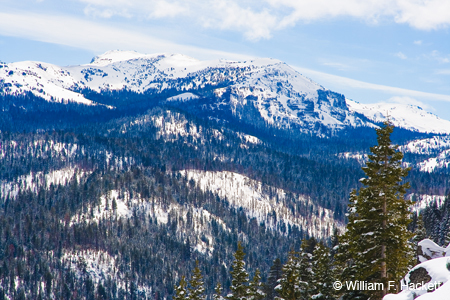
SFGate.com has good news for skiers and snowboarders!
In the Sierra, skiers and snowboarders have rejoiced as wave after wave of fresh powder continues to dump on Tahoe’s mountain resorts. This week’s storms should deliver a decent amount of snow to the Sierra, with up to a foot falling in some areas through Tuesday night.
-Bill at
Cheshire Cat Photo™ – “Your Guide to California’s Wonderland™”
You can view higher-resolution photos at the Cheshire Cat Photo Gallery on SmugMug, where you can also order prints in a HUGE variety of sizes and types, even on canvas and metal! The Cheshire Cat Photo Store on Zazzle® contains a wide variety of apparel and gifts decorated with our images of California. All locations are accessible from here. LIKE Cheshire Cat Photo on Facebook here! If you don’t see what you want or would be on our email list for updates, send us an email at info@cheshirecatphoto.com. Follow us on Twitter at @cheshirkat and on Instagram at: cheshirkat


