Finding snow

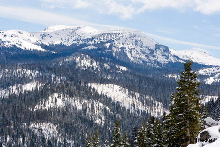
I usually tell people that, living in California, if I WANT snow, I know where to go to FIND it! Well, today, I wanted snow!  More specifically, I wanted to photograph snow on trees and mountains! More importantly, there were no major storms slated for the Sierra in California, and there were no “chain restrictions” – the roads were clear and dry.
The place where I found it was Lake Tahoe, the largest alpine lake in North America. The surface elevation of the lake is 6,225 ft (1,897 m), and Lake Tahoe is the second deepest lake (1,645 feet [501 m]) in the United States, after Crater Lake in Oregon, which is 1,945 feet (594 m) deep. The lake lies on the border of California and Nevada and was formed by geologic block (normal) faulting. The natural history and human history of the lake and its basin are fascinating!
The route that I chose on my way to Lake Tahoe was U.S. Route 50, from Sacramento to South Lake Tahoe, in Eldorado County. The history of U.S. 50 in California is rich and deep, from pioneer days onward. (Today, I noticed a turnoff to the Gold Bug Mine in Placerville. I’ll save it for another day!) South Lake Tahoe has, as its neighbor in Nevada, the city of Stateline, with its gambling casinos. If you are a skier, South Lake Tahoe has Heavenly Mountain Resort, and my trip today passed SEVERAL ski areas.
Finding snow was easy. I KNEW it would be. The snow pack is supposed to be the deepest since 1995, I think. It certainly LOOKED like it! I started to see snow along U.S. 50 at Pollock Pines, which is 3960 feet (1207 m). U.S. 50 passes through the El Dorado National Forest and follows the South Fork of the American River, which originates at Echo Summit near Echo Lake, south of Lake Tahoe. Along the way, I passed through the small communities of Strawberry, Twin Bridges, and Meyers – places that I have not seen in years. We were invited to use the South Lake Tahoe cabin of an acquaintance, when the kids were younger – but that was summertime, and my family does not ski. Near the small, unincorporated area of Phillips (elevation of 6873 feet [2095 m]), I saw the entrance to the Sierra-at-Tahoe ski resort.
Oh! The snow…? It was on the pine boughs and stacked several feet deep on rooftops along the way at the higher elevations. Along the side of the road, the snow depth was much higher than the tops of tour buses!

I started taking photographs at pull-out areas along the steep descent into the Lake Tahoe Basin, along steep, rocky cliffs of the eastern side of the hairpin in U.S. 50 here. (1, 2, 3, 4, 5, 6)
Then, I descended into South Lake Tahoe (1), photographed the lake from the beach at a resort hotel (1, 2, 3, 4, 5), photographed two women with their own camera at their request (of course, I gave each my card), photographed (1, 2, 3, 4, 5, 6) and ate lunch at the Thomas F. Regan Memorial City Beach, and then photographed ducks (1, 2, 3), a half-underwater split-rail fence (1, 2), and mountain reflections in the water (1, 2, 3) of a nature preserve (The Upper Truckee Marsh), right here. Unlike the photo, which shows a creek, the area is now under shallow water!
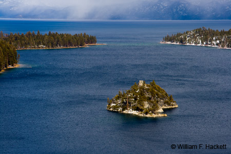
I took the long way home, north on California State Route 89. I stopped on the high, narrow (not much wider than the road, itself!) part of U.S. 89 between Emerald Bay and Cascade Lake, and photographed Emerald Bay and Fannette Island (1, 2, 3, 4), the only island in Lake Tahoe. (Note added April 10, 2011: Fannette Island houses the ruins of “Tea House,” which was constructed by Mrs. Lora Josephine Knight, who ALSO build the 38-room American Craftsman-style mansion on Emerald Bay, Vikingsholm, which I toured with my family on our earlier trip! Mrs. Knight and her husband were the primary financial backers of Charles Lindbergh‘s nonstop solo flight across the Atlantic Ocean in 1927.) Then I drove to a small bridge on 89 that traverses a cascade running down to Emerald Bay and took some more photos (1, 2, 3).

I had decided to drive north on 89 until I reached I-80 near Donner Pass. Since gasoline was $4.039/gallon at Costco this morning (and MUCH higher in the Sierra – I saw $4.379 for regular in Tahoe City), I wanted to maximize my mileage in the Honda Civic by driving highway miles on cruise control, which has been effective in the past. I ALSO decided that I-80 would likely remain open longer than U.S. 50, if a snowstorm came in. I “hung a left” at Tahoe City, at the north end of the lake, and followed 89 along the Truckee River to I-80, which parallels Donner Pass Road to the north of Donner Lake – all named after the ill-fated Donner Party. The route also took me past the entrance to Squaw Valley.
There were snow flurries in the air as I drove north on 89. The flurries snowed harder as I entered Interstate 80 and even harder as I passed signs for Donner Summit! Weather in the Donner Pass area can (obviously) be brutal. Wikipedia has this to say about winters:
“At 415 inches (10.5 m) per year, Donner Pass is one of the snowiest places in the United States. To take advantage of the heavy snows, the Boreal Ski Resort was built to the north. Ski resorts in the Lake Tahoe area report an average of 300 to 500 inches (7.6 to 13 m) of snowfall per season. Winds in the pass can also become extreme and wind gusts in excess of 100 miles per hour (160 km/h) are common during winter storms. Winter temperatures in the area drop below zero several times each year; the all-time record low for California of −45 °F (−43 °C) was recorded at the Boca Reservoir (east of Truckee) in January 1937.”
Needless to say, I wanted to get to lower elevations as soon as possible, PARTICULARLY before any water on the road surface turned to ice. The California Highway Patrol (CHP) had cars evenly spaced in the area, and they were not pulling anyone over. (Californians tend to speed. The CHP in the Sacramento area were not so forgiving, from the number of cars I saw pulled over!) I believe that the officers were present to prevent anyone from getting in trouble if a storm came in.
I watched the altitude markers tick off the elevation in thousands of feet as I descended from the Sierra Nevada. The sky became blue with scattered clouds. The weather became sunny with temperatures in the 60s F in the Central Valley.
I made my way safely home by I-80, I-5, and I-580.
I can’t wait to work on the photos!
-Bill at
Cheshire Cat Photo™ – “Your Guide to California’s Wonderland™”
You can view higher-resolution photos (*generally* 7-30 megabytes, compressed) at the Cheshire Cat Photo™ Pro Gallery on Shutterfly™, where you can also order prints and gifts decorated with the photos of your choice from the gallery. The Cheshire Cat Photo Store on Zazzle contains a wide variety of apparel and gifts decorated with our images of California. Framed prints and prints on canvas can be ordered from our galleries on redbubble®. All locations are accessible from here. Be a “Facebook Fan” of Cheshire Cat Photo here! If you don’t see what you want or would be on our email list for updates, send us an email at info@cheshirecatphoto.com.


